
 Weak steering currents, now and later, are raising issues for Debby's future path and redevelopment.
The Atlantic is likely to be Debby's destination late in the week.
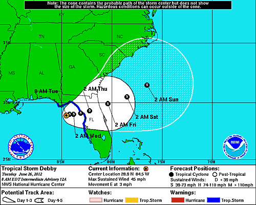
Slow-moving Debby has meteorologists very concerned this week.
Debby was nearly stationary over the northeastern Gulf of Mexico, near the Florida coast, to start the week.
If Debby reorganizes and pokes into the mid-levels of the atmosphere, it is likely to be influenced by upper-level steering winds once again.
"Assuming the system gets its second wind, it is likely to be picked up by a trough over the northeastern United States and pushed eastward across the Florida Peninsula and into the Atlantic," Sobel said.
A trough is a southward scoop in steering winds located high in the atmosphere. In the past, troughs have picked up many tropical systems and swept them out to sea or drawn them northward up the Atlantic coast.
In this case, there is likely to be too much wind shear to allow the system to move very far to the north along the Atlantic Seaboard. A shunt to the east or another stall is possible later this week.
According to Expert Senior Meteorologist Bernie Rayno, "If Debby misses the connection with the trough, its circulation and moisture could linger near Florida for days," Rayno said.
 Tropical Weather Expert Dan Kottlowski is concerned that the system now could stall again late in the week.
"The problem is the trough in the Northeast now will move away late in the week," Kottlowski said.
"If this system moves to (or a new one forms on) the Atlantic side of Florida, it too could hang around for days along the southern Atlantic Seaboard later this week," he added.
A budding, slow-moving system on the Atlantic side would bring increasing wind, building surf and numerous rip currents later this week from West Palm Beach northward to the Grand Strand and the Outer Banks, perhaps similar to what occurred along the Gulf side over the weekend.
Whether or not Debby re-fires, or another system erupts over Atlantic Florida waters, slow movement of the overall situation will continue with ongoing bouts of severe weather and heavy rain.
Significant impact over Louisiana and Texas is off the table at this point as a zone of high pressure sitting over the southern Plains has essentially produced a north to northeasterly flow of dry air over the northwestern Gulf of Mexico.
However, since the system has a large circulation, wave action may continue to propagate outward, affecting some offshore energy and fishing interests in the Gulf until late in the week.
AccuWeather.com meteorologists will be watching Debby closely for redevelopment along the Atlantic coast of Florida and lingering effects over the eastern Gulf as the week progresses.
Interests along the Florida Gulf Coast and along the entire southern Atlantic Seaboard from Florida to North Carolina should continue to monitor Debby and the overall tropical situation this week.
By Alex Sosnowski, Expert Senior Meteorologist – Accuweather.com


No comments:
Post a Comment