Summary:
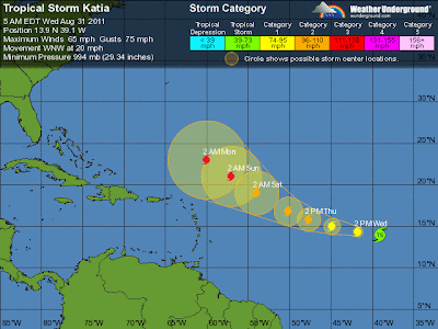
At 5am ET Wednesday, Tropical Storm Katia was located in the eastern Atlantic Ocean about 985 miles west of the Cape Verde Islands, or about 2,775 miles east-southeast of Miami, Florida.
Maximum sustained winds have increased to near 65mph. Katia continues to become gradually better organized in structure and though the storm is currently moving into an area of dry air in the central Atlantic, environmental conditions are largely favorable for additional intensification and the dry air may only limit the rate of strengthening.
The official forecast and computer models continue to indicate that Katia could become a hurricane later today, or at least within the next 24 hours, and potentially a major hurricane within the next 72 hours.
T.S. Katia is moving quickly west-northwest around 21mph, and this general motion but a decrease in forward pace is expected through the next 2-3 days as it is steered around the southern edge of high pressure in the central and western Atlantic before turning more towards the northwest into a weakness in the high pressure ridge.
Computer models are in very good agreement on the system and these models along with the official 5-day forecast track from the National Hurricane Center keeps the system over the eastern and central Atlantic away from any land masses.
However, longer range computer models suggest the storm will move north of the northern Leeward Islands early next week before turning more northward towards Bermuda.
Elsewhere, a tropical wave in the northwestern Caribbean Sea about 375 miles south-southwest of Key West, Florida, is producing a large area of disorganized thunderstorm activity.
Computer models are not being run on the system, but the wave is moving west-northwest around 10-15mph and should move over the northern Yucatan Peninsula today and into the southern Gulf of Mexico tonight or tomorrow.
Though development is not immediately expected, there is a chance for development once it emerges into the Gulf of Mexico. Currently, the National Hurricane Center is indicating only a 10% chance for tropical cyclone formation within the next 48 hours.
Amy Godsey, State Meteorologist
Florida Division of Emergency Management


No comments:
Post a Comment