
 An area of low pressure heading into the eastern Gulf of Mexico by Tuesday will be watched closely for tropical development.
In the meantime, it is helping to ignite torrential downpours across South Florida.
Potential For Tropical Development
The low is located about 100 miles east of Florida, and it developed along a stationary front that has been draped over the western Atlantic.
 After drifting westward across Florida today into tonight, the low will emerge over warm water in the eastern Gulf of Mexico. The warm water and relatively weak wind shear over the Gulf will provide an opportunity on Tuesday into Wednesday for the low to develop into a named storm.
If this system does develop tropically, it will compete with another area of low pressure out over the central Atlantic for the next name on the 2010 Atlantic Hurricane Season list, which is Danielle.
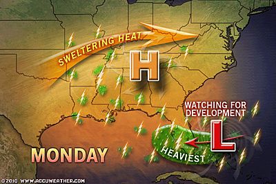
The steering flow created by an area of high pressure dominating the Southeast could draw the system toward the central or western Gulf Coast.
Computer models currently show this feature moving west-northwestward into an area between Louisiana and the upper Texas coast toward the latter half of the week; however, this track and the intensity of the system are far from set in stone at this point in time.
People with interests along the Gulf Coast from Texas to Florida should regularly check back with AccuWeather.com for updates on the potential for tropical development over the next few days.
Torrential Downpours in Florida
Whether the low develops into a tropical system or not, it will continue to enhance showers and thunderstorms in South Florida through at least Tuesday.
Very heavy and slow-moving thunderstorms will unleash enough rain to lead to localized flash flooding and travel delays.
Some communities could be inundated by 2-3 inches of rain during the afternoon and evening.
Miami and West Palm Beach are among the cities and towns that are expected to get drenched.
A few of the storms could also become gusty, causing local damage.
It is not out of the question for the strongest storms to spawn isolated waterspouts or tornadoes.
By Meghan Evans, Meteorologist – Accuweather.com


No comments:
Post a Comment