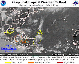
Tropical activity is once again heating up in the Atlantic following the first hurricane of the season last week. Three potential tropical waves are being monitored by forecasters, one of which could become a tropical storm.
A circulation in the northwestern Caribbean where Hurricane Alex originated has the greatest potential for development because it is producing tropical storm force winds at nearby buoys and ships. It is moving west-northwest at 10 to 15 mph toward the Yucatan Peninsula with very warm waters ahead of it and light wind shear to help foster thunderstorm development and organization. If it develops into a tropical storm, it will be given the name "Bonnie."
Two other disturbances scattered from the Gulf of Mexico into the eastern and southern Atlantic Basin are small circulations that have a low chance of development. A low pressure about 125 miles south-southeast of the central Louisiana coast is expected to slowly move north-northwest. Due to its proximity to the Gulf Coast and the hostile wind shear, development with this wave is not likely.
A disturbance approaching the Lesser Antilles will bring heavy rain and gusty winds to the Leeward and Windward Islands, the Virgin Islands and Puerto Rico the next few days. This disturbance is moving west-northwest at 10 to 15 mph. Warm water and lighter wind shear could foster development in the next few days.
The Caribbean and Gulf of Mexico remain prime locations for tropical activity through early July given low wind shear and warm ocean temperatures.


No comments:
Post a Comment