
+copy.jpg) Potential for isolated strong to severe storms Tuesday morning through Tuesday Afternoon.
Potential for isolated strong to severe storms Tuesday morning through Tuesday Afternoon.A storm system will rapidly begin to take shape Monday evening across the Western Gulf of Mexico. As this storm system develops, a warm front will begin to move northward toward the Florida Big Bend and Panhandle.
+copy.jpg)
This warm front will be pushing a cooler and more stable airmass north of the region and ushering in a warmer and more unstable one.
As this warmer air mass begins to lift north and interact with this frontal boundary, an area of showers will develop across North Florida, South Georgia, and Southeast Alabama before sunrise.
Once the warm front moves inland and further north, the more unstable air mass will create an environment that is more favorable for the development of thunderstorms.
.jpg) Some of these thunderstorms could become strong to severe, initially in North Florida in the morning and then later across much of the area by the afternoon hours. Even though this system is less than 24 hours away, there still remains some uncertainty with its track and intensity.
Some of these thunderstorms could become strong to severe, initially in North Florida in the morning and then later across much of the area by the afternoon hours. Even though this system is less than 24 hours away, there still remains some uncertainty with its track and intensity.As a result, the potential for severe weather is also uncertain. This system is quite energetic.
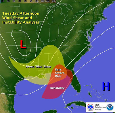
Due to the current predicted track of the storm system, the area of best instability and strongest wind shear will likely overlap late Tuesday morning and afternoon across the Florida Panhandle, Western Florida Big Bend, Southwestern Georgia and Southeast Alabama.
However, due to the uncertainty with the track of this system, there is the potential that more of the instability remains just off shore, thus limiting the potential for severe weather to areas near the Florida Panhandle Coast.
Based on our latest models, we currently expect that more instability will be transported inland, thus we feel the potential for severe weather will extend into much, if not all of our forecast area by the end of the day. Thus, the images that follow are based on the current predicted timing and threat from this system.
Impacts:
* Due to the strong shear and potential for some instability, any storm that becomes severe will have the potential to produce tornadoes. This threat will be maximized as the warm front lifts through the area.
* Once the warm front lifts through the region, any storm that develops will have the potential to produce damaging winds up to 60 mph.
* Locally heavy rainfall could occur with this system with storm total rainfall amounts up to 3
Inches possible, especially in Southeast Alabama and the Florida Panhandle.
Our locally run statistical models place the overall threat for a severe storm as follows:
Summary:
* The potential exists for a few strong to severe storms to develop across the region starting after sunrise on Tuesday morning. These storms will have the potential to produce damaging winds up to 60 mph and isolated tornadoes.
* Locally heavy rainfall is possible with locations in Southeast Alabama and the Florida Panhandle seeing up to 3 inches of rain by the end of the day.
The National Weather Service in Tallahassee will continue to monitor the potential for severe weather today. If you have any questions, please give our office a call at 850-942-8833 or on our toll free line at 800-598-4562 and ask to speak to a meteorologist. We are available 24 hours a day, 7 days a week. You can also reach us on our Southern Linc phone at 1*77*184.


No comments:
Post a Comment